

A voyage to Antarctica’s icy depths has revealed a rich array of marine life and geological features that may shed light on the region’s past and future.
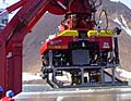
Isis, the UK’s first deep-sea remote operated vehicle, combed the area’s sea bed, diving down to 3.5km (2.2 miles).
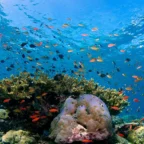
The vessel imaged diverse animals, such as king crabs, anemones and sponges.
It also gave the first view of ancient “meltwater channels”, which will aid understanding of how the Antarctic ice sheet might change in the years ahead.
The expedition to the Marguerite Bay area on the western side of the Antarctic Peninsula marked the inaugural science mission for the Isis remote operated vehicle (ROV).
It is a region that is covered with ice for much of the year, and, until this expedition, its sea floor had never before been scanned in such detail at such extreme depths.
Professor Julian Dowdeswell, director of the Scott Polar Research Institute at the University of Cambridge, was the principal investigator on the cruise.
He told the BBC News website: “This mission exceeded our expectations in terms of both the performance of the ROV and the significance of the scientific data.”
The submersible, which when not at sea is based at the National Oceanography Centre, Southampton, is built to withstand enormous pressure and can dive to depths of 6.5km (four miles).
It is equipped with a number of instruments, including cameras, sonars, and sample-collectors that are deployed using its mechanical arms. It is tethered to its “mothership” – on this expedition the RSS James Clark Ross – with a 10km (6 miles) cable.
Scientists manoeuvre the ROV from a control room onboard the ship, and can see the data it produces in real-time.
Professor Dowdeswell said: “When you are sat there in the control room, surrounded by monitors, you really feel that you are down at the sea bed with the ROV. You have to pinch yourself to remember that you are not.”
Carved bedrock
During the three-week-long expedition, Isis made 15 separate dives, mapping the shallow waters of the bay, the continental shelf edge and the deep continental slope that lies beyond.
One dive on the continental shelf in about 600m (2,000ft) of water revealed a series of channels into the bed rock, providing the team with the first detailed look at some of Antarctica’s glacial history.
Professor Dowdeswell explained: “About 18,000 to 20,000 years ago, ice extended out to the shelf edge, over 300km (190 miles) from its present position.”
Water, melted from the ice-sheet bed, flowed in these subglacial channels, which unlike normal rivers have both uphill and downhill slopes due to the pressure of the overlying ice.
He said: “This is the first time we have been able to take a really good look at these channels – some were almost 100m (330ft) deep. We flew the ROV up and down their sides, giving us some impressive images of subglacial fluvial erosion and an insight into the rates of past water flow.”
The meltwater channels will aid understanding of the processes taking place at glacier beds and the stability of the past and present Antarctic ice sheet.
“Now we can see the shape of them, we can work out how quickly the water pumped out of them. This will help us to better understand glacial melt.”
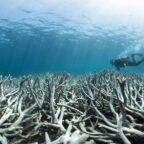
Other geological finds included rocky debris dropped by icebergs as the ice sheet retreated 10,000-15,000 years ago, spotted from a 3.5km (2.2 miles) deep dive; and ridges of glacial sediment marking the more recent retreat of the ice over the past few decades, observed from a dive close to the current glacial edge.
Climate threat
In addition to surveying the geology, the mission team was also interested in finding out about the fauna of the area.
Professor Paul Tyler, a deep-sea biologist at the National Oceanography Centre, used Isis to survey the sea creatures of Marguerite Bay.

Social Profiles