


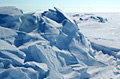
An island of ice the size of Manhattan has drifted into a remote channel and jammed itself in.
The Ayles Ice Island changed the Arctic map by breaking free from the Canadian coast two years ago.
Scientists have been tracking the progress of this monster iceberg amid fears that it could edge west towards oil and gas installations off Alaska.
The creation of the island is seen by many scientists as a key indicator of the rapid warming of the Arctic.
Ayles Ice Island is vast, measuring about 16km (10 miles) long and five kilometres (three miles) across.
In May, I joined a team that staged a dramatic landing by ski-plane on to the island itself to carry out the first scientific analysis.
Satellite pictures monitored by the Canadian Ice Service show how it has drifted along the coast (310km since May) and is now wedged into the Sverdrup Channel, an inlet between two of the Queen Elizabeth Islands that make up the northernmost limits of the Canadian High Arctic.
No danger
One of the scientists on the May expedition, Dr Luke Copland, assistant professor at the University of Ottawa, says this year’s unusually low concentrations of sea-ice – which freezes and thaws with the seasons – may explain how the ice island ended up in its current position.
However, given the potential hazard of such a vast block of ice, this may be the safest outcome for the time being.
Dr Copland told me: “The main message now is that the Ayles Ice Island is out of the danger area for the oil rigs in the Beaufort Sea. Now that it has moved out of the wide open Arctic Ocean and into the Queen Elizabeth Islands it is likely to stay stuck in there.”
During the expedition, Dr Copland planted a satellite beacon to provide the most accurate possible track of the island’s movements.
Sadly the beacon has now stopped working – either because it has run out of battery power or more likely because its radio path to the satellites above is somehow obscured.
Dr Copland said: “The fact that we were receiving partial signals from the beacon suggests that something was blocking it. The most obvious candidates are that it has fallen into a crack in the ice or a pond of meltwater; or been covered over by a snowdrift. Beyond that we can’t tell anything.
“There is a possibility that the beacon will come back to life if the obstruction moves out of the way.”
In the meantime, satellite pictures will be the only source of news about the fate of the island. And given the rapid retreat of sea-ice – heading for a record low this year – scientists will want to keep a close watch on this new feature of the Arctic geography for years to come.
Source: bbc.co.uk

Social Profiles