
A NASA and French Space Agency (CNES) spacecraft designed to continue a long-term survey of Earth’s oceans has arrived at Vandenberg Air Force Base, Calif., for final launch preparations.
The new satellite will study ocean circulation and the effect oceans have on weather, climate and how Earth is responding to global climate change.
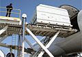
The Ocean Surface Topography Mission, called OSTM for short, will be flown on the Jason-2 spacecraft, which was transported on April 24 from its manufacturer, Thales Alenia Space, in Cannes, France, to Toulouse, France.
It was loaded onto a Boeing 747 aircraft for its trans-Atlantic journey and after refueling in Boston, it arrived April 29 at Vandenberg Air Force Base. Following final tests, it will be integrated onto a United Launch Alliance Delta II launch vehicle in preparation for a planned launch in June.
With the launch of this satellite, the science of precisely measuring and studying the height of the sea surface across Earth’s oceans will come of age.
Continuous collection of these measurements began in 1992 with the NASA/CNES Topex/Poseidon mission and continued in 2001 with NASA/CNES’s Jason-1 mission, which is currently providing near-real-time data to a variety of users. The addition of the National Oceanic and Atmospheric Administration (NOAA) and the European Organization for the Exploitation of Meteorological Satellites (EUMETSAT) as partners on OSTM/Jason-2 begins transitioning the responsibility for collecting these data to weather and climate forecasting agencies, which will use them for short-range and seasonal-to-long-range ocean forecasting.
The 15-plus-year climate data record that this mission will continue is the only one capable of addressing how ocean circulation is linked to climate change and how global sea level, one of the most important consequences and indicators of global climate change, is changing.
Satellite observations of Earth’s oceans have revolutionized our understanding of global climate by improving ocean models and hurricane forecasts, and identifying and tracking large ocean/atmosphere phenomena such as El Ni

Social Profiles