


A lack of high quality seabed habitat information has always constrained capture fisheries and shellfish farmers in their endeavour to manage fishing grounds and reduce the environmental impact of fishing, as well as comply with marine nature conservation legislation.
To help industry map marine habitats and species in a given area, Seafish has been trialling its ‘Basic Seabed Habitat Mapping’ system with fishers in Sussex and Devon.
Under this system, basic information on the type and location of the habitat and the location of important species is collected, supported by a photographic or video record and a sketch map of the site.
Excellent video footage is now available from the first seabed trial which was carried out in July jointly by Eastbourne fishermen and the Sussex Sea Fisheries Committee (SFC).
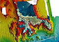
The MFV Halycon, which was skippered by Graham Doswell, used acoustic ground discrimination sonar and underwater video to collect video survey data on the location of reefs, important fishing grounds and sensitive areas.
“This information is crucial,” said Graham, Chairman of the Eastbourne Fishermen’s Association. “The Sussex SFC is consulting on a fisheries management plan which considers, from a fisheries perspective, the sensitivity and vulnerability of the seabed to various fishing activities and whether more action is required to further protect it.”
This view was endorsed by Robert Clark of the Sussex SFC. “Fishermen in Eastbourne have really taken the initiative here and shown how fishers can positively contribute to marine conservation.
This work is a very valuable addition to our knowledge and management of the fisheries in this area, and the capture of video footage means it can be communicated to a wide audience,” he said.
The second seabed mapping trial formed the basis of an extensive survey of Devon’s Salcombe Estuary during September. Local fishermen Kevin Oakman (MFV Pimpernell II) and Matthew Yeoman (MPV Ann) worked with Devon SFC and the crew of patrol vessel FPV Drumbeat to map sensitive seagrass beds adjacent to their traditional fishing grounds.
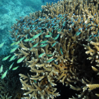
The estuary contains a variety of seabed habitats, including the dense areas of eel grass which are important settlement and nursery grounds for juvenile scallops. These beds are vulnerable to mobile gear such as the scallop dredges traditionally employed over the winter.
“There is a lot of local interest in this area about the effect scallop fishing has on the seabed and, in particular, on sensitive habitats. The video footage we collected is very timely.
It has given us, and the Devon SFC, a much better understanding of the seabed and the location of sensitive habitats in advance of the winter scallop fishery,” said Kevin Oakman.
This was reiterated by Tim Robbins, Deputy Chief Fishery Officer of the Devon SFC. “We were very impressed with the video equipment developed by Seafish and Dr Andy Woolmer and the data will be invaluable. Having used the video equipment with the GPS facility I have seen the ease with which it can be used.
I can think of numerous other areas that could be surveyed, and types of fishing gear and their interaction with the marine environment that could be studied.”
“This is only the start,” said Mark Gray, Environmental Assessment Officer at Seafish. “The seabed mapping guidance is part of a toolkit we are developing to help industry reduce the environmental impact of fishing and show that fishing can be compatible with marine nature conservation interests.
“Video survey data is a key part of these trials. Crucial information is provided that will be used in mapping habitats, that not only support their target species but also act as spawning and nursery areas. This type of survey can also be used to understand the vulnerability of these features to certain activities and also provide information on the biodiversity of the seabed.
More trials will follow.”
Source: fishupdate.com

Social Profiles