


The great sweep of water around Planet Earth has been captured from space in greater detail than ever before. New observations from Europe’s Goce gravity mapping satellite have allowed scientists to plot ocean currents with unprecedented precision.
Understanding gravity is fundamental to being able to track the direction and speed of water across the globe.
The data should improve the climate models which need to represent better how oceans move heat around the planet.
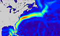
Very strongly represented in the new map is the famous Gulf Stream, the most intense of all the currents where water zips along at velocities greater than one metre per second in places.
“The Gulf Stream takes warm water from the tropics and transports it to higher latitudes, and that warmth is released to the atmosphere and keeps the British Isles, for instance, much warmer than they would otherwise be,” said Dr Rory Bingham from Newcastle University, UK.
“When this water has reached higher latitudes, still, because it is by then cold, salty and dense, it will sink; and you get this overturning circulation that helps regulate Earth’s climate,” he told BBC News.
Dr Bingham presented his ocean circulation data using the latest information from Goce at the recent American Geophysical Union (AGU) Fall Meeting, the largest annual gathering of Earth and planetary scientists.
The European Space Agency (Esa) satellite was launched in March 2009, and is delivering a step change in our vision of how gravity varies across the globe.
Contrary to popular perception, the pull of gravity is not the same everywhere. There are actually very subtle differences in the tug exerted by the mass of the planet from one place to the next.
In the oceans, this has the effect of making water bulge over great submarine mountain ranges and to dip over the deepest ocean trenches.
Goce, which circles the Earth from pole to pole, carries a state of the art gradiometer to sense the variations on a scale better than 100km.
The information is critical to oceanographers attempting to trace the currents.
If they compare the gravity information with measurements of sea surface height made by other spacecraft, they can establish a much better picture of where water is piled up and where it is likely to flow and at what speed.
Very accurate data on currents is already obtained from drifting sensors thrown into the water, but these are necessarily just point measurements.
Oceanographers would hope therefore to combine the truly global perspective they can only get from Goce with the “ground truth” they can retrieve from drifters.
Add in further data collected about sea temperature and it becomes possible to calculate the amount of energy the oceans are moving around Earth’s climate system.
Computer models that try to forecast future climate behaviour have to incorporate these details if they are to improve their simulation performance.
“The new information coming from Goce is amazing,” said Dr Bingham. “We’re getting down to very fine scales now. It’s incredible to think for example that we can sense from space very small circulation features like the Mann Eddy, a persistent pocket of water in the Atlantic that just goes around and around.”
The ocean circulation information presented at AGU was built using just two months of Goce gravity data.
Scientists expect to construct improved maps when they understand better how the satellite’s sophisticated instrument behaves and the observations accumulate.

Social Profiles