

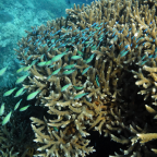

Images from the Great Barrier Reef will soon be coming to Google Maps as the Catlin Seaview Survey maps the world’s largest coral reef system.
“The idea is to test the project on the Great Barrier Reef in 2012, and beyond that to roll the project out globally,” Richard Vevers, founder of Underwater Earth and director for the project.
The project aims to educate the public about the marine ecosystem which has many puzzles for scientists and threatened by global warming.
The Catlin Seaview Survey aims to carry out a comprehensive survey on the health of the reef and educate the public about the importance of the marine ecosystem.
“Our mission is to reveal our oceans to the world and we want to go across iconic locations all over the world. We’re looking at nine to 10 new locations next year and beyond that, it’s how quickly we roll this project out,” said Vevers.
Challenging
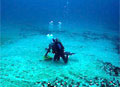
Doing the research is challenging because of the alien environment, one of the research divers on the project said.
“We are in remote locations so we have to have redundant systems for everything. It’s always very challenging,” research diver Richard Fitzpatrick told News24 from about 40m below the surface of the water.
“The limitation of working under water is breathing. I got a scuba tank on my back at the moment which limits the amount of time I can spend in the water working,” he added.
Vevers said that the images captured by the remotely operated vehicle (ROV) will become available in Google Maps so that internet users would be able to follow the dive virtually, similar to the way people are able to explore cities with Street View.
“Anybody will be able to drop into a location and go off and follow the route of the scooter, and look round in full 360

Social Profiles