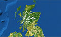
Marine scientists are to create 3D images of the seabed off the north of Scotland to help identify habitats that need conservation.
Waters around Noss Head near Wick and the Southern Trench, a deep channel in the Moray Firth, will be surveyed.
The Scottish government will use the images to inform marine conservation and development policies.
“Acoustic multi-beam” survey techniques will be used create the 3D images in the project, starting on Tuesday.
The Minch and the Sound of Canna, as well as Linnhe, Etive, Leven and Eil lochs will also be surveyed later in the year.
The work, which is funded by Marine Scotland, is being carried out by Scottish Natural Heritage (SNH), the British Geological Survey and the Northern Lighthouse Board as part of the Scottish marine protected area project.
I...
Read More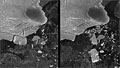


Social Profiles