
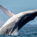


Whales may be largest animals on Earth, but that still doesn’t mean they’re easy to find in the vast oceans they inhabit. In the past, researchers have used acoustic monitoring, aerial surveys and binoculars to keep track of the marine mammals. Each of those techniques, however, can only survey a tiny slice of the oceans. Jonathan Amos at the BBC reports that a new study shows whales can be counted from space, giving conservationists a massive new tool to survey and monitor to creatures.
Researchers have tried to count whales using satellite imagery in the past with limited success since the resolution just wasn’t fine enough. For the new study in the journal Marine Mammal Science, researchers from the British Antarctic Survey and the University of Cambridge gave it another shot, using the WorldView-3 satellite operated by DigitalGlobe. That eye in the sky has a resolution down to one foot, about 1.6 times better than previous commercial satellites, making spotting whales from afar possible.
To test the system, the researchers selected seven bits of ocean known to be whale hotspots near Hawaii, Mexico, Argentina and Italy, covering 1,930 square miles or roughly the size of the state of Delaware. Using both automated systems and the human eye, they examined the images for whales. The images are so good that in many cases researchers can even see the flippers and flukes of the animals.
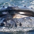
According to the study, some whales are easier to detect than others. Fin whales and grey whales are relatively easy to pick out because their body color contrasts well with the blue of the ocean. Southern right whales are harder because they blend in. Humpback whales also have ocean-colored camouflage, and they are so acrobatic that their splashing often obscures images of them. The study proves that whales can be imaged from space, and knowing what to look for will help researchers revise their search algorithms, eventually leading to improved automated whale watching systems.
“This is a potential game-changer—to be able to survey whales unhindered by the cost and difficulty of deploying planes and boats,” co-author Jennifer Jackson of the British Antarctic Survey tells the BBC. “Whales are a really important indicator of ecosystem health. By being able to gather information on the grandest scales afforded by satellite imagery, we can understand something more generally about the oceans’ health and that’s really important for marine conservation.”
Counting animals from space is not new—researchers have recently begun to count albatross using satellites and another project uses crowdsourcing to hunt for seals in Antarctica. But the scope of the whale project is much bigger—instead of focusing on a known colony of birds or seals, researchers are scouring vast expanses of ocean for the whales and identifying them by species.
“This is really cool to expand capabilities with the imagery,” Michelle LaRue, University of Minnesota ecologist who worked on the seal project tells Brian Kahn at Earther. “I think whales in particular pose an extra level of complexity due to the need for calm sea state and their being at the surface, but my hope is this technology can add to other datasets from aerial and shipboard surveys.”
The BBC reports that the next step in the study will be to search for fin whales in the Ligurian Sea, a marine protected area in the northwest of Italy. Conservationists are concerned about ship strikes in the area and hope to learn more about the movement patterns of the whales. But it is almost impossible to survey the nearly 14,000 square-mile area via boats and planes and would take forever for human researchers to examine using satellite photos. Instead, the team hopes to use the area to refine their whale-spotting algorithms, which, as Earther’s Kahn reports, still need a little work.


Social Profiles