

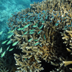

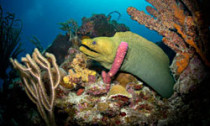
Coral reefs teem with a diverse array of life and colour, but in many places around the world, their future is uncertain. The Caribbean, where this vibrant moray eel was shot by an advance party for the mappers, is having a particularly bad time of it. Over the past 50 years, 80 per cent of the coral reef cover there has been lost to a perfect storm of pollution, overfishing, rising temperatures and ocean acidification. Researchers worry that others could soon be in a similar state.
More detailed, comparable information on how reefs are faring around the world is vital if we are going to be able to protect them.
One group attempting to do this is the Catlin Seaview Survey. They have already photographed the length of the Great Barrier Reef, and yesterday they announced they are now expanding their efforts into the Caribbean and Bermuda. The pictures and footage they take will be made publicly available and will provide a baseline snapshot that researchers can refer to when looking at how corals have responded to future climate change.
The survey relies on several specialised panoramic cameras, capable of taking multiple pictures at a time every three seconds. The cameras are attached to a motorised scooter steered by a diver, which drives the camera forward.
The camera set-up is 16 times faster than other similar technologies at cataloguing data, says project director Richard Vevers. “We’re hoping that it will allow us to map all the world’s main coral reefs over a three year period.”
Globally, it is estimated that coral reefs help support half a billion people through tourist revenue as well as protecting the shoreline from erosion and storm surges.


Social Profiles